Groundwater Extraction Causes US Cities to Sink
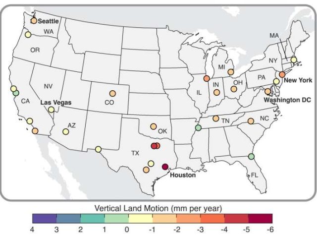
A new study published in Nature Cities reveals that all 28 of the most populous U.S. cities are experiencing land subsidence, with many undergoing uneven vertical land movements that may pose serious risks to infrastructure. The research utilizes highly detailed satellite data to map surface elevation changes down to 28-meter grids, uncovering that in 25 of these cities, at least two-thirds of the land is sinking. In total, roughly 34 million residents are affected.
The primary driver of this subsidence is groundwater extraction, which causes underlying aquifer sediments to compact when water is removed faster than it is replenished. In some areas, additional contributors include oil and gas extraction, the natural rebound from glacial melting, and even the weight of dense urban infrastructure, as seen in New York City.
Houston is the fastest-sinking city, with over 40% of its area subsiding at rates exceeding 5 millimeters per year. Other cities with notable sinking zones include Dallas, Fort Worth, New York, San Francisco, and Las Vegas. In some places, localized subsidence reaches up to 5 centimeters per year.
The study also highlights differential motion, where adjacent urban areas sink or rise at different rates. Though this affects only about 1% of the land area across the cities studied, these zones typically lie within urban cores and affect approximately 29,000 buildings. Differential movement increases the risk of infrastructure damage, such as tilting buildings or destabilized roads and railways. San Antonio, Austin, Fort Worth, and Memphis were identified as the cities with the greatest proportion of at-risk buildings.
While flood-related subsidence becomes critical only when land dips below certain thresholds, the study emphasizes that even minor vertical shifts can strain infrastructure. Earlier research cited by the authors suggests that subsidence may be an underrecognized factor in past building collapses.
Policymakers are urged to integrate land movement data into urban planning and construction codes. Proposed solutions include improved stormwater management, land-raising, green infrastructure such as artificial wetlands, and targeted building retrofits. The study emphasized the importance of moving from risk identification to proactive mitigation and adaptation strategies.
Read the full article at Phys.org.
Photo Credit: Adapted from Ohenhen et al., Nature Cities, 2025